United Nations convention on the law of the Sea (UNCLOS) provides the legal framework for dividing maritime space between neighbouring and facing states, but it gives only general guidance on how to draw the line. The Bay of Bengal Maritime Boundary Arbitration, 2014 is landmark application of those rules. The tribunal delimited the territorial sea, the exclusive economic zone (EEZ) and the continental shelf within 200 nautical miles, and it resolved long standing dispute over the land boundary.
The matter was on three issues: provisional equidistance line, tribunal delimiting the continental shelf and created "grey area" arrangement. The Award aims at "equitable solution".
Legal Framework
UNCLOS distinguishes the maritime zones a coastal state can claim. The territorial sea extend up to 12 nm and is under full sovereignty under Article 2 & 3. The EEZ extends upto 200 nm and carries sovereign rights over resources under Article 55-57. The continental shelf is the seabed and subsoil of the natural prolongation of the land territory and can extend beyond 200 nm up to the limits.
Where two states overlap, UNCLOS uses different standards:-
Territorial sea: In Absence of agreement, neither State may extend its sea beyond the median (equidistance) line, unless historic title or other special circumstances justify a different line.
EEZ and continental shelf: Delimitation is to be effected by agreement on the basis of international law in order to achieve an equitable solution. The treaty gives no method which leaves the work to tribunals.
Continental shelf is natural prolongation of land territory and gives formula extending it from 200 nm to 350 nm, claim submits to the Commission on the limits of Continental Shelf (CLCS).
Evolution of Delimitation Methodology
In 1958, continental shelf convention favoured equidistance and special circumstances. The North Sea continental shelf case, 1969 (Judgment) [1969] ICJ Rep. 3 rejected equidistance as mandatory and emphasised equitable principles.
In Romania V/S Ukraine, [2009] ICJ Rep. 61 set three stages:-
Draw a provisional equidistance line using appropriate base points.
Consider relevant circumstances that may require adjusting that line to reach an equitable result.
Check that the result is not grossly disproportionate between ratio of coastal lengths and the ratio of maritime space allocated.
International Tribunal for the Law of the Seas (ITLOS) had applied this approach in Bangladesh V/S Myanmar,ITLOS Rep. 2012, 4 the first international judgment to delimit the continental shelf beyond 200 nm.
Bangladesh V/S India, PCA Case No. 2010-16
Background & Facts:
The Bay of Bengal is bordered by India Bangladesh and Myanmar. Bangladesh's coast is markedly concave so a simple equidistance line drawn between neighbours on either side tends to cut coastal state off from the open sea. Bangladesh therefore argued for angle-bisector approach, while India defend equidistance.[Nicaragua V/S Honduras, ICJ, 2007]
Bangladesh and India failed to settle their Maritime boundary for decades despite negotiations from 1974. Bangladesh initiated arbitration against India in 2009[3] similarly against Myanmar. The Permanent Court of Arbitration (PCA) acted as registry, hearings were held in the Hague in late, 2013 and award came on 7th July 2014. India Bangladesh both accepted it.
The issue earlier dealt with Radcliff delimitation in 1947 between Pakistan and India. Now Bangladesh and India followed by Bagge Tribunal clarified. On the issue where land starts (New Moore) South Talpatty island which formed in 1970 cycle was under dispute.
Tribunal Judgment
The page also contains a hand-drawn map showing India, Bangladesh, Myanmar and the maritime boundary, with delimitation lines and 200 nm markings.
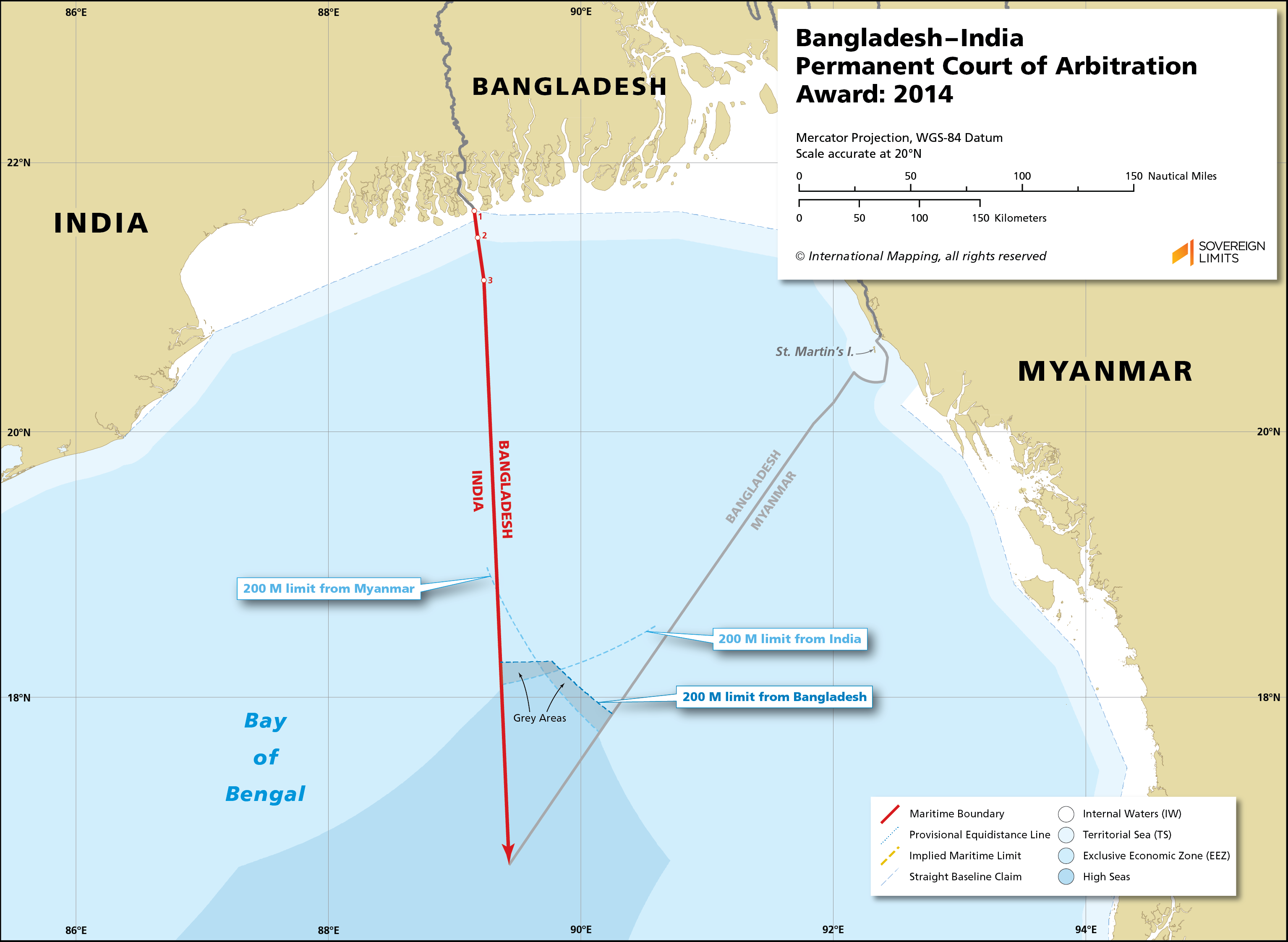
The map is for illustrative purposes only.
The base map is taken from ETOPO2.
1. Jurisdiction: India raised objections, including the tribunal could not delimit shelf beyond 200nm before commission on the limits of continental shelf (CLCS) recommendations. It held that part XX gone it competence to delimit territorial sea, CLCS's technical role does not displace tribunal's role in delimitation between states.
2. Land boundary terminus: The tribunal had to settle where the maritime line starts. It examined the Radcliffe and Bagge Awards and concluded that the terminus lay at the mouth of Haribhanga River, placing it so that the line could be drawn to the sea. This avoided having to decide the status of South Talpatty, which the tribunal treated unnecessary to resolve for delimitation.
3. Territorial sea: India contended that an earlier tacit or implicit understanding existed from the 1970s negotiations. The tribunal found no binding agreement on the territorial sea. It then applied Article 15 and drew a line based on equidistance, with an adjustment to deal with the terminus, rather than 180° Azimuth that Bangladesh had asked for.
4. EEZ and continental shelf within 200 nm: The tribunal found that equidistance would produce a cut-off effect on Bangladesh's concave coast, which effect on Bangladesh, following approach used by ITLOS, it adopted an adjusted line using the angle bisector of the two states' coastal fronts at an azimuth of 177°30' which tribunal considered more equitable.
5. The "Grey area": The adjusted line leaves an area beyond Bangladesh's 200nm limit but within India's 200 nm. Hence Bangladesh holds the seabed and subsoil, while India holds the water column (EEZ). The tribunal expected the states to co-operate to manage resource exploitation there. This is the same device ITLOS used in the 2012 case and it remains controversial.
Outcome: Bangladesh was awarded roughly 19,467 sq. km of the approximately 25,602 sq.km disputed area, while India received remainder, about 6100 sq. km. The tribunal's result also gave Bangladesh a path to the outer continental shelf, which matters for hydrocarbon and fisheries resources.
Significance
1. Confirmation of the three-stage method: The tribunal treated it as the standard approach subject to adoption. It acknowledged that equidistance is not always practicable and that other methods, like the angle bisector, are acceptable.
2. Concavity as a relevant circumstance: The case provides strong authority that a concave coast can justify adjustment where equidistance causes sever cut-off.
3. Delimitation can be decided beyond 200 nm, with CLCS recommendations: It's held that Judicial delimitation is distinct from CLCS's technical work.
4. The tribunal set a high bar for proving an implicit agreement on a maritime boundary, requiring clear evidence of consent, because boundary agreements are exceptional importance.
5. Tribunal respected existing boundaries. Where tribunal used Radcliffe and Bagge Awards.
6. Island status issues left unresolved: The tribunal avoided ruling on whether South Thalpatty qualified as an island or low tide elevation, which leaves doctrinal questions about unstable features open.
Criticism
1. The angle-bisector method can appear subjective and the tribunal's selection of coastal fronts affects the result.
2. The grey area creates practical difficulties in resource management, because two stages hold different rights over the same location, which risks conflict.
3. The tribunal and ITLOS have restricted the notion of CLCS's technical role, and stretched that can entitle to award beyond 200 nm.
4. Lack of clear rules means outcomes are less predictable, undermining certainty in negotiations. India accepted the result but had argued for narrower adjustment.Conclusion
The decision removed a source of bilateral tension and supported a better relationship between India and Bangladesh. It was followed by the 2015 Land Boundary Agreement protocol exchanging enclaves, so that the two states settled both their land and maritime frontiers within a short period.
Bangladesh gained legal certainty for offshore exploration and its "blue economy," strategic while India secured defined maritime zones to its east. The case is also frequently cited as evidence that compulsory UNCLOS dispute settlement works.
The Bay of Bengal Maritime Boundary Arbitration demonstrates the flexibility and functionality of UNCLOS. By applying a three-stage method, adjusting for concavity, jurisdiction over outer continental shelf, and managing the grey area through a shared rights arrangement, the tribunal produced a result both states accepted. It shows that legally binding, peaceful settlement of maritime boundaries is attainable, and it contributes to a developing body of jurisprudence on how equity is operational in delimitation.
Bibliography
1) United Nations Convention on the Law of Sea.
2) Bay of Bengal Maritime Boundary Arbitration (Bangladesh V/S India), PCA Case No. 2010-16, Award, 7 July 2014.
3) Case | PCA-CPA
https://share.google/TnPKZgjZbk43adKbh
4) AJIL | Cambridge Core
https://share.google/SeElomSyuWVJ5Bju